![]()
Panna is the twenty second Tiger
Reserve of India and fifth in Madhya
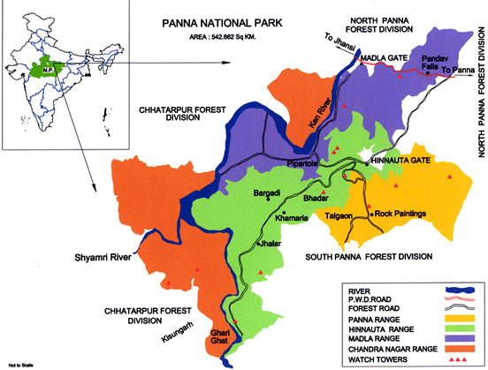
Pradesh . The Reserve is situated in the Vindhyan Ranges and spreads over Panna
and Chattarpur districts in the north of the state.
Panna National Park was created in 1981. It was declared a Project Tiger Reserve by Government of India in 1994. The National Park consists of areas from the former Gangau Wildlife Sanctuary created in 1975. This sanctuary comprised of territorial forests of the present North and South Panna Forest Division to which a portion of the adjoining Chhatarpur forest division was added later. The reserved forests of the Park in Panna district and some protected forests on Chhatarpur side were the hunting preserves of the erstwhile rulers of Panna, Chhatarpur and Bijawar princely states in the past.
 |
The location of the National Park
is also important because it is situated at a point where the continuity of the forest
belt, which starts from Cape Comorin in the south, is broken and beyond this the great
Gangetic plains begin. This area is also the northern most tip of the natural teak
forests and the eastern most tip of the natural Kardhai (Anogeissus
pendula) forests.
The Ken
river , which flows through the Reserve from south to north, is home for Gharial
and Mugger, and other aquatic fauna and is one of the least polluted rivers and a
tributary of Yamuna. It is one of the sixteen perennial rivers of Madhya Pradesh and
is truly the life line of the Reserve. Ken offers some of the most spectacular scenery
to the visitor while it meanders for some 55 km through the reserve.
The terrain of the reserve is
characterised by extensive plateaus and gorges. The reserve which has a bench topography,
can broadly be divided into three distinct tablelands on Panna side: the upper Talgaon
Plateau, the middle Hinnauta plateau and the Ken valley. Series of undulating hills
and plateaus rise on the other side of Ken river in Chattarpur district.
|
|
The
park along with the surrounding territorial forest area of North and South Panna divisions
is the only large chunk of wildlife habitat remaining in North Madhya Pradesh in otherwise
fragmented forest landscape of the area. Panna National Park represents one of the
important Tiger habitats of Central Indian Highlands along with its associated species.
The
location of the National Park is also important because it is situated at a point
where the continuity of the forest belt, which starts form Cape Comorin in the south,
is broken and beyond this the great Gangetic plains begin. This area is also the northern
most tip of the natural teak forests and the eastern most tip of the natural Kardhai
(Anogeissus pendula) forests.
Forests
of Panna National Park along with Ken Gharial Sanctuary and adjoining territorial
divisions form a significant part of the catchment area of the river Ken with a total
length of 406 km runs for about 72 kms through this catchment.
Apart from their conservation values, the forests of Panna have a variety of tourism resources capable of providing rich and diverse cultural, historical, religious wilderness and adventure experience. Panna offers tremendous tourism potential being situated very close to the ancient temple down of Khajuraho, which is already on the international map of tourist destinations.
|
|
||
|
Total Area |
- |
1645.08
sq. km.
|
| Core | - |
542.66
sq. km.
|
| Buffer | - |
1002.42
sq. km.
|
| Kenghariyal Sanctuary | - |
78.53
sq. km.
|
| Panna (Gangau) Sanctuary | - |
45.20 sq. km. |
|
Longitude |
- |
79045?E to 80009E |
|
Latitude |
- |
24027N
to 24046N |
|
Altitude |
- |
211.2 metres
(near Ken river,Compt. 228, Madla Range) to 540 metres (a hillock near Talgaon, Compt.
1340, Panna Range) |
|
Geographic Landmarks |
- |
The reserve
is located on either sides of Ken river which flows from south to north through the
Lower Vindhyan Formations within the park. |
|
Rainfall |
- |
1100 mm, average |
|
Temperature |
- |
Mean Minimum:
50C |
Contact Us :
Field Director
Panna Tiger Reserve
Panna - 488001
Madhya Pradesh
Ph - 07732-252135 (off), 252120 (Fax)
email:
fdptr82@gmail.com
We Love Our Panna Tigers and Panna People
|
|
|
| Home| The
Park | Biodiversity | The
Management | Research | |